


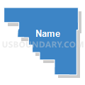
Precinct 23, Lyon County, Kansas
About
Outline

Summary
| Unique Area Identifier | 585753 |
| Name | Precinct 23 |
| County | Lyon County |
| State | Kansas |
| Area (square miles) | 59.66 |
| Land Area (square miles) | 59.17 |
| Water Area (square miles) | 0.49 |
| % of Land Area | 99.17 |
| % of Water Area | 0.83 |
| Latitude of the Internal Point | 38.68830850 |
| Longtitude of the Internal Point | -96.00844740 |
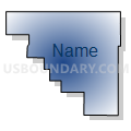
Maps


Graphs
Select a template below for downloading or customizing gragh for Precinct 23, Lyon County, Kansas


Neighbors
Neighoring Voting District (by Name) Neighboring Voting District on the Map
- Barclay Township Voting District, Osage County, KS
- Dragoon Township Voting District, Osage County, KS
- Grant Township Voting District, Osage County, KS
- Harveyville Township Voting District, Wabaunsee County, KS
- Precinct 21, Lyon County, KS
- Precinct 22, Lyon County, KS
- Precinct 26, Lyon County, KS
- South Burlingame Voting District, Osage County, KS
- Wilmington Township Voting District, Wabaunsee County, KS
Top 10 Neighboring County Subdivision (by Population) Neighboring County Subdivision on the Map
- Burlingame township, Osage County, KS (1,680)
- Wilmington township, Wabaunsee County, KS (716)
- Plumb township, Wabaunsee County, KS (631)
- Reading township, Lyon County, KS (487)
- Agnes City township, Lyon County, KS (430)
- Waterloo township, Lyon County, KS (284)
- Grant township, Osage County, KS (266)
- Ivy township, Lyon County, KS (261)
- Dragoon township, Osage County, KS (202)
- Barclay township, Osage County, KS (195)
Top 10 Neighboring Unified School District (by Population) Neighboring Unified School District on the Map
- Osage City Unified School District 420, KS (3,757)
- North Lyon County Unified School District 251, KS (3,417)
- Wabaunsee East Unified School District 330, KS (3,186)
- Burlingame Public School Unified School District 454, KS (1,637)
Top 10 Neighboring State Legislative District Lower Chamber (by Population) Neighboring State Legislative District Lower Chamber on the Map
- State House District 51, KS (22,133)
- State House District 59, KS (21,469)
- State House District 76, KS (20,876)
Top 10 Neighboring State Legislative District Upper Chamber (by Population) Neighboring State Legislative District Upper Chamber on the Map
- State Senate District 18, KS (67,438)
- State Senate District 19, KS (65,414)
- State Senate District 17, KS (62,307)
Top 10 Neighboring 111th Congressional District (by Population) Neighboring 111th Congressional District on the Map
Top 10 Neighboring Census Tract (by Population) Neighboring Census Tract on the Map
- Census Tract 102, Osage County, KS (2,893)
- Census Tract 4832, Wabaunsee County, KS (2,544)
- Census Tract 6, Lyon County, KS (2,462)
- Census Tract 103, Osage County, KS (2,074)
Top 10 Neighboring 5-Digit ZIP Code Tabulation Area (by Population) Neighboring 5-Digit ZIP Code Tabulation Area on the Map
- 66523, KS (3,833)
- 66413, KS (1,802)
- 66423, KS (985)
- 66868, KS (764)
- 66431, KS (671)
- 66833, KS (536)
- 66830, KS (262)